


IOSH Railway Group: Enhancing the Safety of Track Workers with Geofencing Q&A
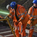
The ever-changing face of technology means at times it can be difficult for Safety Professionals to keep up to date with the technology available for enhancing the safety of trackworkers. To show how the OWL safety system uses geofencing technology to help rail-based teams visualise and understand their surroundings, increasing situational and hazard awareness and keeping teams safe whilst working on the railway environment infrastructure we presented the below presentation with IOSH.
You can watch the webinar on-demand below:
We have also received some additional questions after the presentation which you can find the answers to below.
Yes, please click on this link to view the video Rail Sector Can you Geofencing Solutions by OWL (owl-bi.com)
Yes, it is possible to add a new zone representative of a worksite (or other item) at any stage. Generally, the portal is used to create the zones/geo-fences based on pre-planned access. However, zones can be created at the point of work provided that the user creating the zone had the relevant permissions and access the portal, which would require an internet connection.
The devices alert prior to going flat to give the user staged warnings that the battery level is low allowing a user sufficient time to act. The device will not go flat without giving the user these warnings. If the battery does go flat, the last known position of the device prior to power running out would be recorded on Live View on the portal.
The devices alert prior to going flat to give the user staged warnings that the battery level is low allowing a user sufficient time to act. The device will not go flat without giving the user these warnings. If the battery does go flat, the last known position of the device prior to power running out would be recorded on Live View on the portal.
The system is currently in use in multiple sectors and with many customers, the portal records all data generated from the devices that are allocated to specific projects, we do not conduct analysis on the data, but this can be pulled directly by the customer into reports or dashboards to help deliver improvements. In terms of the pilot with Network Rail, this data is being collated and analysed by them. Based on Onwave privacy policy we would need each Customer to authorise release of that information to provide this data.
If the devices are turned on then their location would be visible in Live View on the portal, and so it would be clear straight away that the operatives were not wearing them. The feedback we have had from the teams during the pilot in Southern has been positive and the Network Rail standard sets out clear policies in terms of how the data is used.
Geofences are virtual barriers which are created within a Web Application so they can be created from any location. Once created and referenced Geofences can be reused, started and stopped etc. The pilot with Network Rail Southern uses zones for cyclical maintenance possessions, as well as signal line blocks and so all of the zones need only to be created once and stored in a library. The zones can also be used for fixed locations associated with a project which is the case with other customers.
This is the terminology that is used in the Network Rail Standard, and we are not currently aware of any intention from Network Rail to change this.
The use of geofencing went through national consultation with the trade unions in 2022. Individual routes have been conducting local consultations and or reaching local agreement with the unions, the methodology used by Network Rail has varied across regions and routes
Yes, the devices can be used to report inactivity by a user. The devices also have SOS functionality and a ‘fall’ alert where any sudden change in vertical position will notify the supervisor (or other manager) who can then ensure that the correct assistance is provided.
Yes, this was part of the Product Acceptance process, which included EMC and other radio-based testing. In reality the wearable devices are very similar to a mobile phone.
Yes, as long as they have a device attached to them. We provide two other devices that are more appropriate for plant and equipment that use GNSS location technology, these are lower cost but are not as accurate as the Plus devices.
Yes, the device will automatically go into an unsafe mode, this mode will alert the user by flashing red, providing an audible ‘beep’ and display ‘unsafe’ on the screen. The device will automatically connect back to the platform via the cellular networks when mobile signal is restored.
From our research there is nothing similar currently being used in Europe, with the accuracy of location tracking defined by Network Rail.
We are not overly familiar with ILWS (Inductive Loops Warning System) and why this system is no longer used. This way be to do with the move away from Red Zone working and the reliable detection of trains. Geofencing solutions are designed to keep users outside of designated zones (so would be used to keep users where lines are under possession/ protection)
Part 1 – No there are two other approved suppliers of geofencing technology for Network Rail.
Part 2 – Our product does not have approval for use on London Underground. however, we do not believe that this is a major obstacle, the challenge with the covered section of London Underground is the ability to obtain a GPS signal from the Satellites.
The commercial model is based on the provision of the OWL platform, this includes the platform, devices (including data charges/ RTK service charges) and the mobile app. This means that service is offered on a hire model. The cost is dependent on the number of devices required, the mix of people and plant, the duration of the hire period and the level of managed service support and professional service needed (e.g. Training, onsite support). We are happy to provide a quotation on request.
Any administration associated with zones, users, plant etc can be completed on a laptop, desktop or ipad by logging into the portal We do also have a specific Mobile App which can be downloaded onto a device or mobile phone. This mobile app is designed to be used by field users so is predominantly focused on interactions with the portal rather than the planning and setup phase. Both options are available with the standard user licence.
The devices work in deep cuttings providing they can receive satellite and cellular signal. The devices do not currently work in tunnels or indoors however they have passive provision to use Ultra-Wide Band which in conjunction with beacons will enable them to be used under cover. This is currently being developed and we would hope to make this available some time in 2024.
The OWL platform is designed to provide greater than 99.95% uptime, it is developed on Microsoft Azure meaning it is highly available and scalable. In terms of the devices these supplied on a managed service basis so in cases of faults or issues they are replaced by Onwave. The devices are turned on and off making it difficult to provide specific RAMS figures related to the device.
In order for the device to work it needs to be connected to a mobile network, Each OWL device is capable of connecting to all four mobile networks (in the UK) as well as other networks outside of the UK. If the area does not have any mobile coverage the device will move to Unsafe Mode as described above.
Yes, the devices can be configured to alert based on both static and dynamic geofences. In order to create a dynamic (moving) zone, the zone must be associated with an active device, this device can then be attached to a moving item such as a digger arm or item of plant. The geofence will then move as the item of plant moved and trigger alerts to users that also have a wearable device in the same way as fixed/static geofences.
The battery life for the devices can be up to 3 years as long as they are maintained correctly. They take up to 4 hours to charge from flat to 100% and last up to 12 hours whilst being used on site.
Yes, if the devices loses either GNSS signal or cellular coverage it will go into ‘unsafe mode’ where it will alert the user with a red flashing LED and a single beep until the device reconnects and gains back its accuracy. The device is not designed for use indoors/ in tunnels so we would recommend setting up alerts and zones at the tunnel portal to highlight this to users. As soon as signal, accuracy or zone sync is lost devices go into unsafe mode.
Yes, if the devices loses either RTK signal or cellular coverage it will go into ‘unsafe mode’ where it will alert the user with a red flashing LED and a single beep which will repeat on a 30second basis (configurable) until the device once again becomes safe.


